Hello BackYardGeology readers! This week we decided to talk about something that is a world wide issue and impacts millions of people! This is a somewhat complicated topic as there are many different components that can interact, but it is an important topic. The topic of discussion this week is land subsidence.
What is Subsidence?
Land subsidence is the sinking of the Earth’s surface (either sudden or gradual) as materials below the surface are removed (whether that be water or rock/soil)1. The most obvious case of this that may come to mind is a sinkhole. You have likely seen pictures of these in places like Florida, as the entire state is prone to them. These features occur because water soaks into the ground but has nowhere to go and dissolves the rock/soil (usually limestone which dissolves easily, check out our post on the effects acid rain has on rocks rich in carbonate minerals) ultimately creating a cavity below the surface. Eventually it is expressed as a hole on the surface.
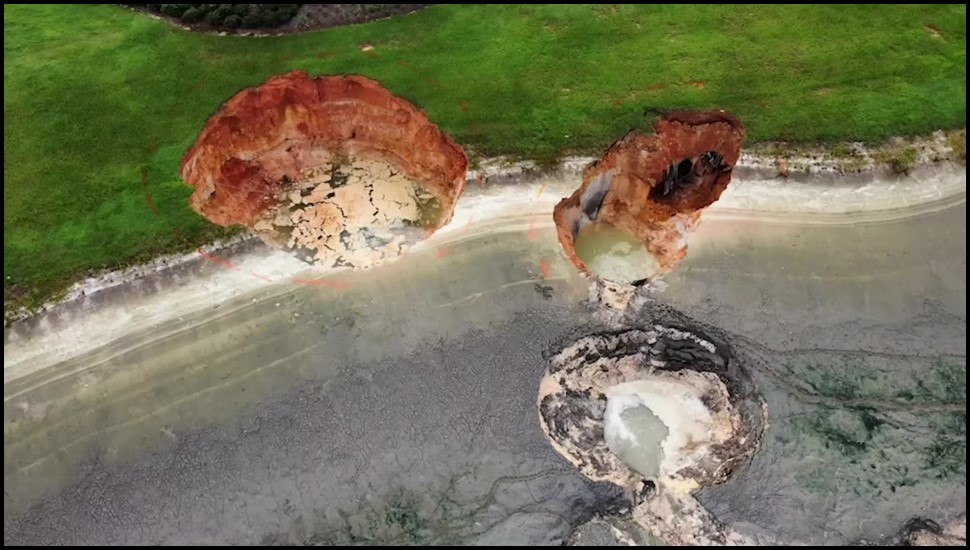
While sinkholes are typically a sudden expression of the ground collapsing and lowering, the more gradual type of subsidence typically takes place on a much larger scale and is not always as obvious. This gradual subsidence is typically the result of groundwater withdrawals.
Groundwater Withdrawals and Land Subsidence
Before we go into groundwater pumping, let’s discuss what groundwater is and how removing it in excess can set the stage for land subsidence issues. As its name suggests, groundwater is water that is stored below the Earth’s surface. The figure below shows a simplified expression of groundwater below the surface.
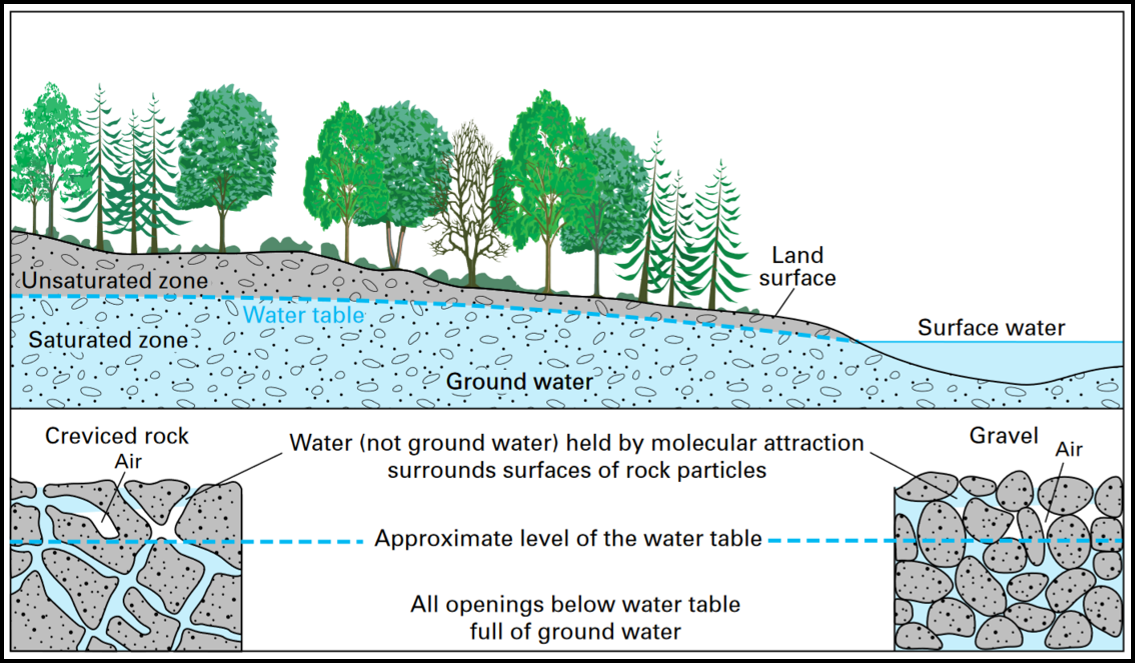
It is commonly stored in what are called aquifers. When the subsurface material is primarily sand, it allows for water to percolate and be stored in between the individual grains of sand (their pore spaces). This is traditionally what geologists consider to be a good aquifer. Other types of material, such as shale, made up of primarily clays is not a good aquifer because the clays are thin and stack up on top of each other, leaving no spaces for water to be stored (a unit like this is called an aquitard). These aquifers naturally restore themselves, the groundwater naturally circulates through them over time. With rain, runoff, snow-melt, etc ., they are ‘recharged’ and the water level can be maintained.
When humans begin to pump the water out of the ground at a rate that exceeds that of the natural recharge, well that is when things can turn sour. You see, the deeper you go, the more pressure on the aquifer materials from the overlying material (we learned about this last week in our discussion of pressure on magma beneath the surface). So as you remove more and more water, the weight from the overlying material will cause those valuable pore spaces between the sands to collapse and become compacted. Once they are compacted, that process can not be undone, so the result is land subsidence as the material shifts due to the loss of the water that was essentially holding everything in place.
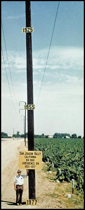
A famous example of this is the San Joaquin Valley in CA. The figure below shows land subsidence from over pumping of groundwater from 1925-1977. With groundwater withdrawal mitigation efforts, the rate of subsidence can be slowed.
As I mentioned, this is a worldwide issue as many places are prone to subsidence. The figure below shows the regions around the world where up to 19% of the global population faces a high probability of impacts from land subsidence.
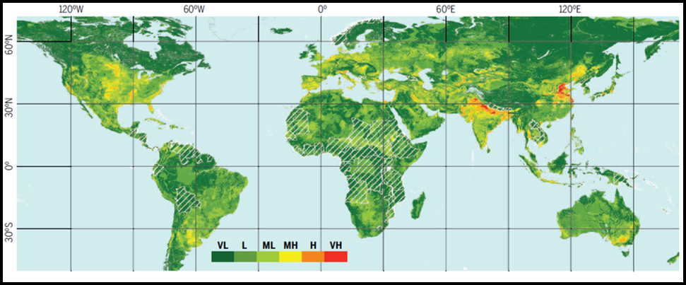
This land subsidence can and will lead to urban infrastructure damage over time. Cracks in foundations of buildings and flooding in areas that were never prone to it, are really good indicators that the land is subsiding.
How is Land Subsidence Scientifically Measured?
Measuring land subsidence ultimately requires understanding how elevations are changing over time. This is typically done using a combination of methods; GPS (global positioning system) and InSAR (interferometric synthetic aperture radar) measurements. InSAR is used to map land-surface deformation. Satellites orbiting the Earth take repeated radar images of the same locations on the Earth’s surface over time2. These images are later combined and analyzed with GPS data in order to determine changes in the Earth’s surfaces. Not only is this technique used for subsidence, it is also commonly used to monitor areas with earthquakes to evaluate how the land is changing as a result of the seismic activity as well as to look at the inflating and deflating of active volcanoes.
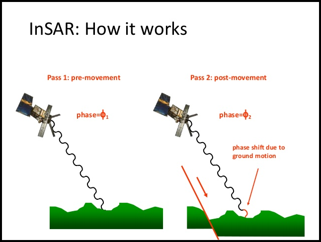
Once subsidence in a region is located, steps can be taken to help determine the cause and if possible slow the rate of subsidence, especially if the cause is over withdrawing of ground water.
References:
1Land Subsidence, United States Geologic Survey, https://www.usgs.gov/mission-areas/water-resources/science/land-subsidence?qt-science_center_objects=0#qt-science_center_objects Accessed 10/10/2021.
2InSAR – satellite-based technique captures overall deformation “picture”, United States Geologic Survey, https://www.usgs.gov/natural-hazards/volcano-hazards/insar-satellite-based-technique-captures-overall-deformation-picture Accessed 10/10/2021.
3Herrera-García, G., Ezquerro, P., Tomás, R., Béjar-Pizarro, M., López-Vinielles, J., Rossi, M., Mateos, R.M., Carreón-Freyre, D., Lambert, J., Teatini, P., Cabral-Cano, P., Erkens, G., Galloway, D., Hung, W.C., Kakar, N., Sneed, M., Tosi, L., Wang, L., Ye, S., 2021, Mapping the global threat of land subsidence; Science, V. 371, p. 34-36.
