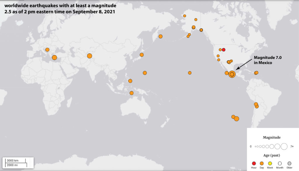
Earthquakes: movement of the Earth’s crust that can cause extreme property damage and loss of life. Most of us think of earthquakes as occurring in very specific locations around the world: California, Japan, Chile, Alaska, and most recently the devastating earthquake in Haiti. These earthquakes are generally larger and release more energy, indicated by a number called a “magnitude” that ranges from less than 1 to a 10 (the largest earthquake ever recorded was a magnitude 9.5 earthquake in Chile in 1960). However, earthquakes actually happen every day all over the world (according to the United States Geological Survey earthquake database, 43 earthquakes of at least a magnitude 2.5 have happened in the past day alone as of this writing!)
The key to understanding where earthquakes occur and why they occur lies in the focus of today’s post: faults. A fault is the fracture along which blocks of rock move relative to each other during an earthquake. While you may immediately jump to thinking of well-known and very active faults, it’s quite likely that a fault (though perhaps a small or very old one) exists somewhere within your own community. So this week, we will focus on some lesser known faults here in the northeastern United States (not an area currently well-known for earthquakes) to begin to understand faults. And, just like most geologists, the ability to visit the locations of famously active faults is not only a goal of ours, but a likely future post (here’s looking at you, San Andreas).
Types of faults
Before we look at our fault examples, let’s talk a bit about the three major types of faults that exist. All of these faults are defined based on the types of rock movement they cause. Normal faults cause one rock block to move down relative to another. Normal faults are often found in regions where the Earth’s crust is being pulled apart (where tension is the overwhelming force). Thrust faults cause one rock block to be thrusted (see what they did there?) over another rock slab. So, one rock block moves up relative to another. Thrust faults occur in regions where compression is the overwhelming force, often during times of mountain building (we call these “orogenies”). Finally, strike-slip faults occur when one rock block moves either right or left laterally relative to another rock block. Faults form during times when rocks are put under immense strains and stresses. So these definitions are highly simplified in that, sometimes, rock movement occurs in many different orientations within the same geologic location and time (we’ll discuss one of these cases in our example faults below!)
Spotting those lesser known faults
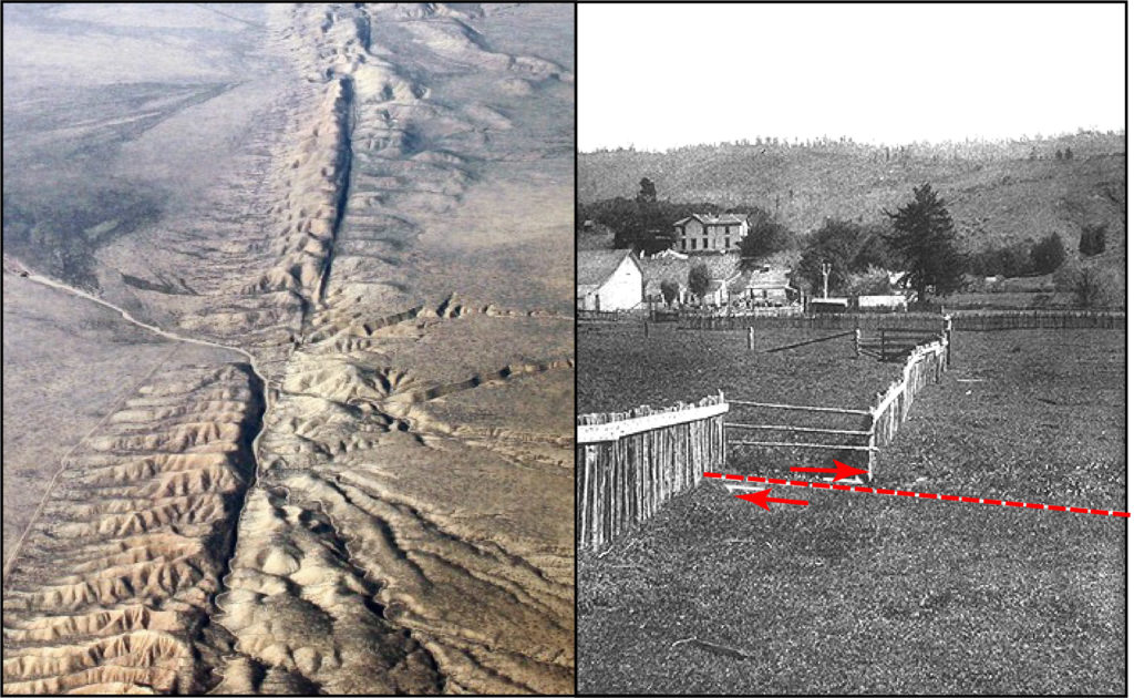
One of the key features indicating movement of rock along a fault is displacement. Something isn’t quite where you think it should be. For large faults, like San Andreas, locating the fault can be quite easy. For example, you can see the large linear “trace” (where the fault intersects the ground surface) of the fault in the picture on the left and the displacement of a fence after the 1906 San Francisco earthquake in the picture on the right.
Okay, so how do we identify a fault that hasn’t moved for millions of years or is much smaller than the San Andreas fault? Some faults do not result in any surface evidence of displacement and so we need special geophysical tools to identify them (we call these “blind faults”1). However, in the faults we will look at next, you will be able to identify their existence through the displacement of rock layers, linear features, or unexpected changes in surface elevation.
Burlington, Vermont
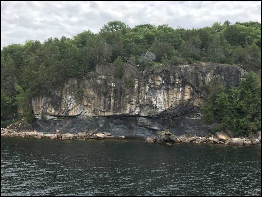
Let’s use what we know about faults so far to identify our first example fault: is it normal, thrust, or strike-slip? This fault is located at the edge of Lake Champlain in Burlington, Vermont at a location fittingly called “Lone Rock Point”2. If you look at the picture below, you will see that there is a really sharp contact, meaning a very distinct boundary, between the lower, dark grey rock and the upper, tan rock. Contacts like this aren’t unusual in the geologic record (a discussion of these types of contacts will make another great future post!) What is somewhat weird about these two rock layers is that the tan rock is actually older than the dark grey rock.
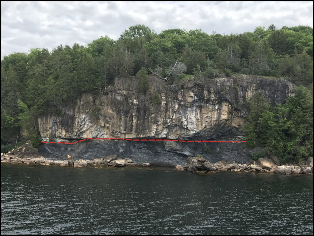
Rock layers are a lot like cake layers: if nothing funky has happened (and, believe us, lots of funky things can happen), then the oldest rock layers will be on the bottom and the youngest rock layers will be on the top. This is especially true for sedimentary rocks like the ones here at Lone Rock Point. In baking, you have to make the cake layers on the bottom before you put more layers on top. In geology, we call this the Law of Superposition.

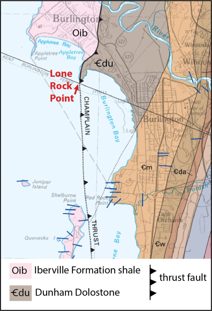
So the big question is: how did the older rock get on top of the younger rock? The rocks you see here are the result of movement along a thrust fault. This stretch of rock is part of the Champlain Thrust Fault, a fault that was last active around 450 million years ago during the mountain building episode known as the Taconic Orogeny. The Taconic Orogeny occurred when today’s east coast of North America collided with another landmass. This is the orogeny that was partially responsible for building the Green Mountains in Vermont3. The upper, tan colored rock is the Dunham Dolostone, formed about 500 million years ago when Vermont was surrounded by a warm shallow sea. The lower (and younger!) dark grey rock is the Iberville Shale, formed in the middle Ordovician (about 470 – 460 million years ago) when fine-grained mud was deposited in deeper ocean water. Overall, the Champlain Thrust displaced these rocks about 35 to 50 miles, pushing the older dolostone over the younger shale2. We can see the location of the Champlain Thrust in the geologic map below. At Lone Rock Point, we can see the shale coming into contact with the dolostone at a thrust fault (black line with triangular teeth). The triangles sit on top of the upper rock block (here, the dolostone!)4.
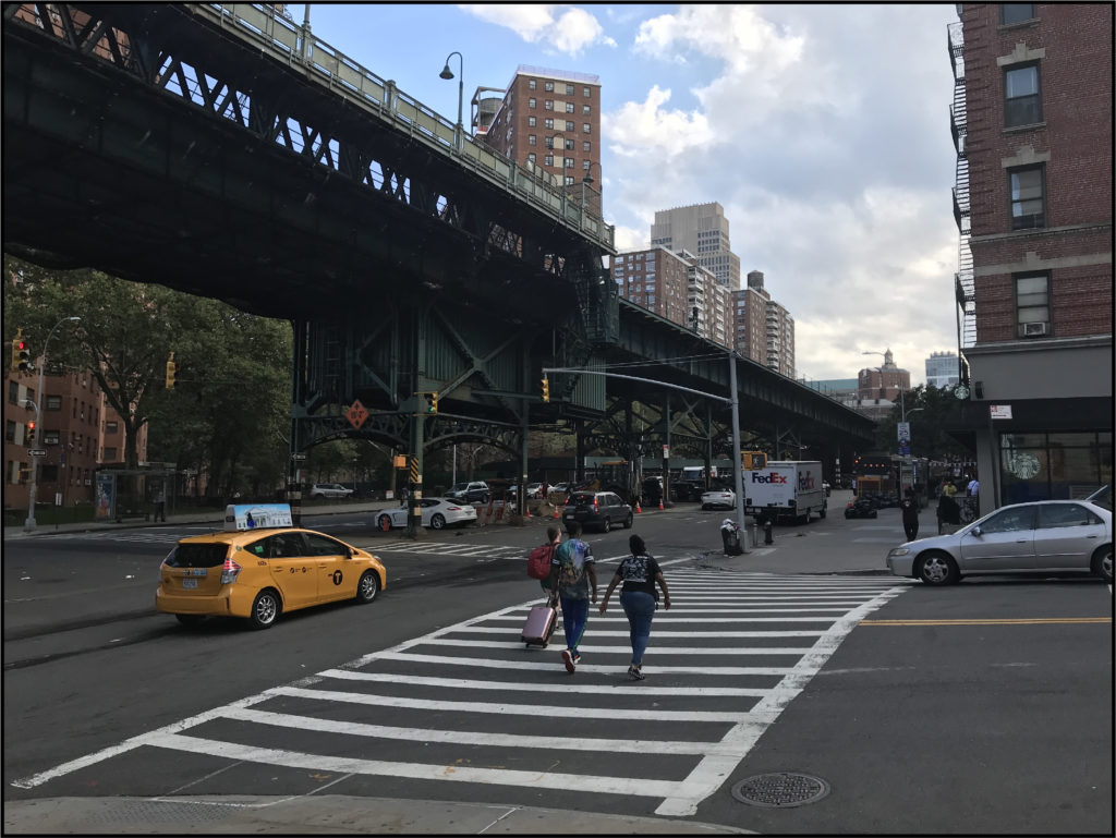
New York City
As we’ve previously discussed during our post on boudinage, the New York City area has had quite a tortured geologic history in that many of its rocks have been melted, folded, and (yes!) even faulted as a result of millions of years of geologic forces. The 125th street fault, for example, runs from the Hudson River where it intersects 125th street, crosses Manhattan and into Queens5. The fault has actually made its presence known throughout the city with an earthquake as recently as 20 years ago. On January 17, 2001, New Yorkers experienced a magnitude 2.4 earthquake with a hypocenter (location beneath the Earth’s surface where the fault ruptures, or first moves) that was 7 km (4.3 miles) beneath the Upper East Side along the 125th street fault6.
The 125th street fault is an oblique strike slip fault7. Now, we know what strike slip means….but oblique?? An oblique strike slip fault is a fault that results in both a lateral AND vertical displacement of the rock blocks. In the case of the 125th street fault, it mostly acts like a strike slip fault but also has some motion similar to a normal fault. So what?? Well, movement on this fault has helped result in a dip in the elevation of the street surface. So 9 blocks south at 116th street, the street elevation is about 140 feet above sea level and the subway trains move underground (like you would expect). At the 125th street station, however, the elevation of the street is only about 50 feet above sea level and the subway train rides along an elevated, outdoor track8.
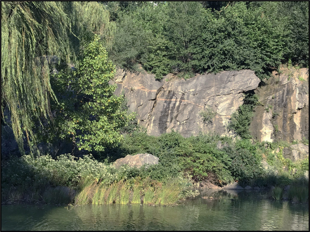
Spot the fault!
The faults that you may find in your own region of the world may not be quite as long as the Champlain or 125th street faults. However, keep your eyes wide open for evidence of displacement in the rock record as small, unmapped faults that have long stopped moving can go unnoticed by all but the trained eye (or Backyard Geology reader). For example: can you spot the fault in the picture below?
References:
1United States Geological Survey Earthquake Glossary. Blind thrust fault. https://earthquake.usgs.gov/learn/glossary/?term=blind%20thrust%20fault, accessed 8 September, 2021.
2Stanley, R.S. and Roy, D.C., 1987. The Champlain thrust fault, lone rock point, Burlington, Vermont. Northeastern Section of the Geological Society of America: Geological Society of America Centennial Field Guide, 5, pp.225-228.
3University of Vermont. Lake Champlain Thrust Fault: Geologic History
4Ratcliffe, N.M., Stanley, R.S., Gale, M.H., Thompson, P.J., Walsh, G.J., Rankin, D.W., Doolan, B.L., Kim, J., Mehrtens, C.J., Aleinikoff, J.N. and McHone, J.G., 2011. Bedrock geologic map of Vermont (No. 3184). US Geological Survey.
5Sykes, L.R., Armbruster, J.G., Kim, W.Y. and Seeber, L., 2008. Observations and tectonic setting of historic and instrumentally located earthquakes in the greater New York City–Philadelphia area. Bulletin of the Seismological Society of America, 98(4), pp.1696-1719.
6Armbruster, J. Manhattan Earthquake, Columbia University, The Earth Institute News Archive, January 18, 2001, https://www.earth.columbia.edu/news/story1_2_01.html, accessed 8 September, 2021.
7Merguerian, C., 1996. Stratigraphy, structural geology, and ductile-and brittle faults of New York City. In Benimoff, AI and Ohan AA, chm., The Geology of New York City and Vicinity, Field guide and Proceedings, New York State Geological Association, 68th Annual Meeting, Staten Island, NY (pp. 53-77).
8Baskerville, C.A., 1982. The foundation geology of New York City. Rev. Eng. Geol, 5, pp.95-117.