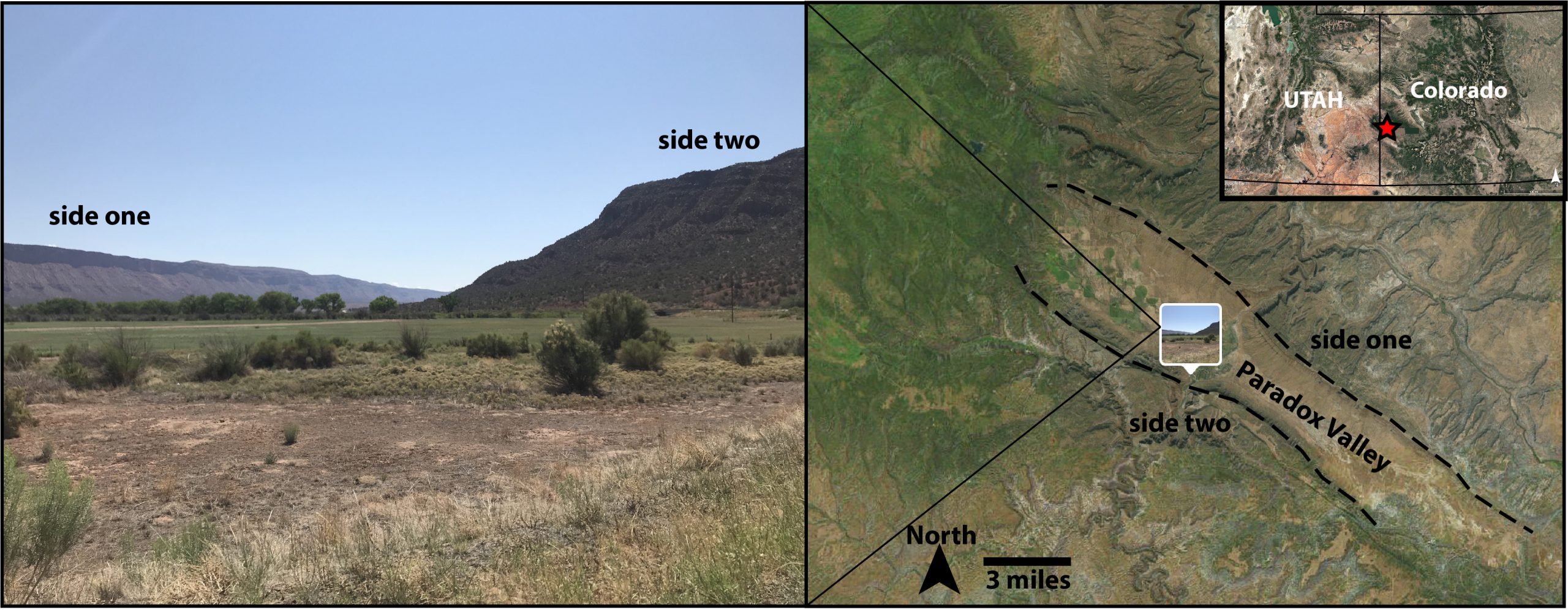
This week, we are going to take you into the role of a field geologist: looking at clues to figure out how geological structures formed. Even though the structures we’ll talk about in this post are not likely found in your backyard, a key player in this story is something you may have recently sprinkled on a batch of fresh french fries. That’s right! This week, our story involves salt and its pivotal role in the formation of Paradox Valley along the border between Colorado and Utah.
Mystery number one: a river (doesn’t) run through it??
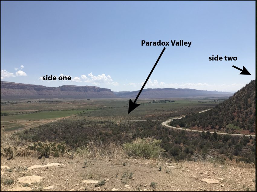
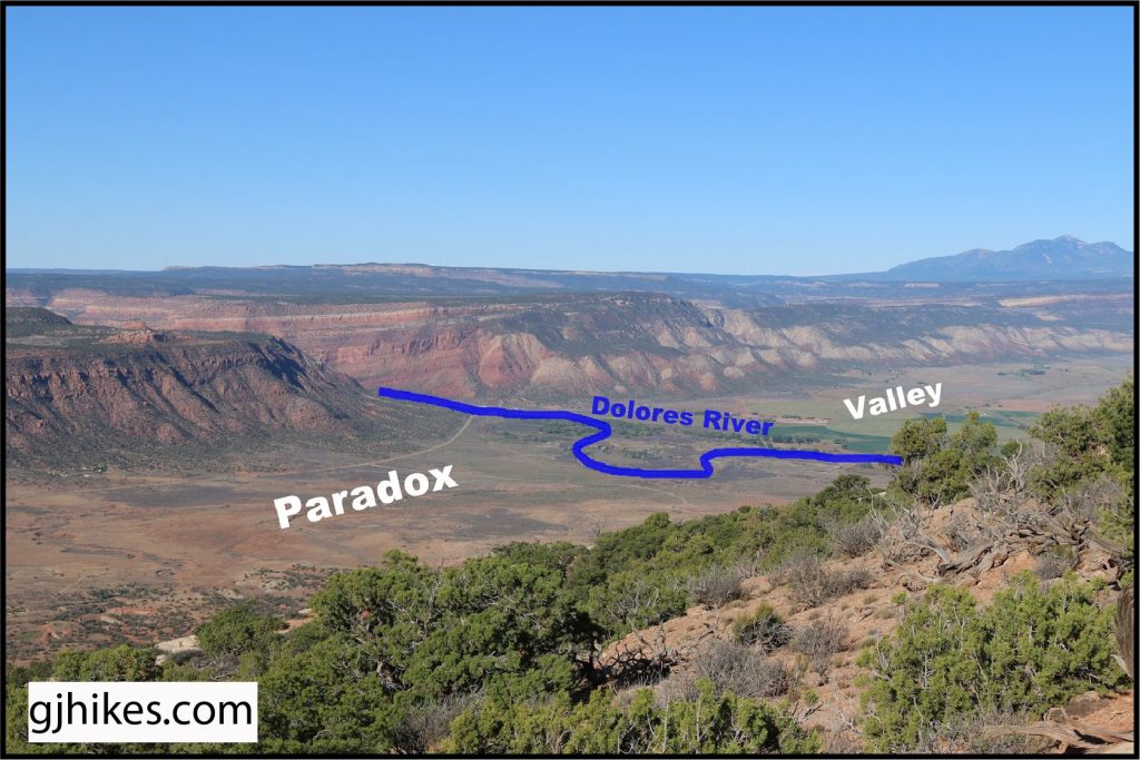
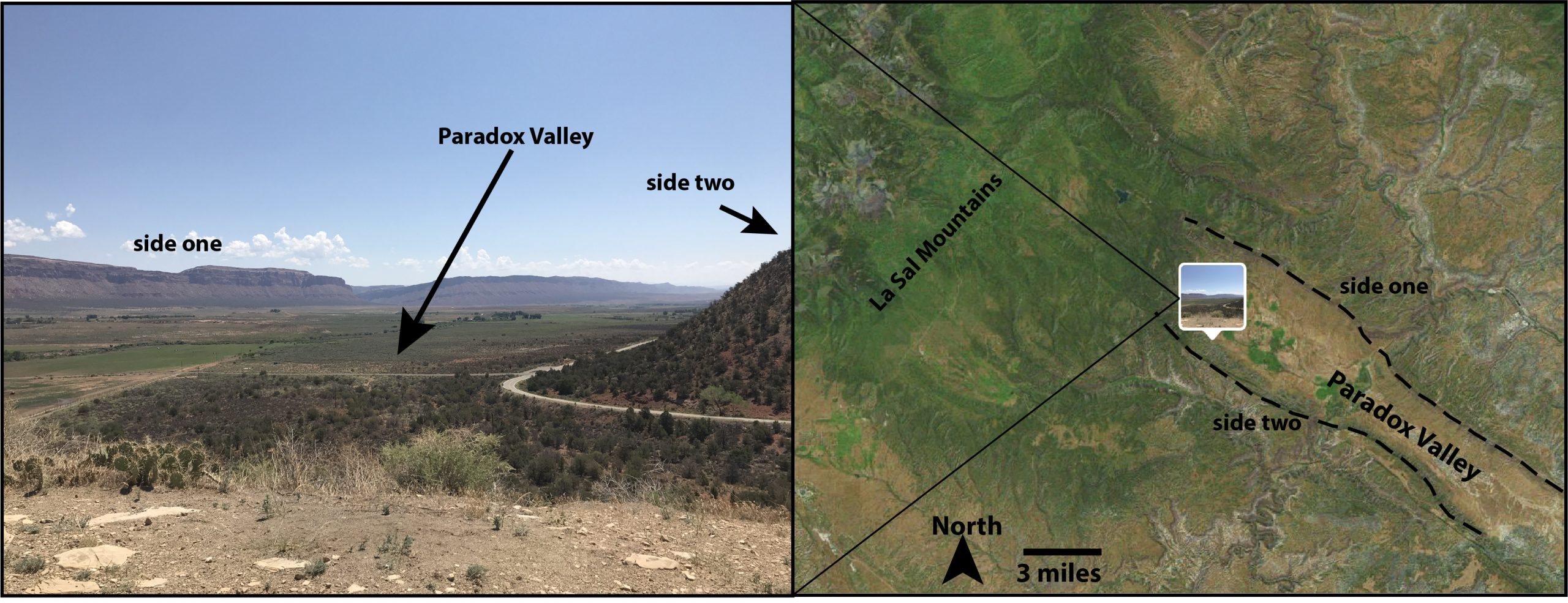
The story of Paradox Valley starts with the name: Paradox. A paradox is something that seems to have two explanations that contradict each other or that has an answer that completely goes against what we would logically expect. The history of how Paradox Valley got its name begins with what it does not have: a river running through the middle of it. When you picture a valley bordered by rock cliffs on either side, you will likely find a river in the very center. Why? This is because rivers are excellent at cutting through rock, helping to form the canyons (here’s looking at you, Grand Canyon) and gorges (remember the Rio Grande Gorge in Taos, New Mexico we talked about in our first vlog post) that we all know and love. Paradox Valley does have a major river in the region, the Dolores River. However, instead of running through the valley, the Dolores intersects the middle of the valley (see the figure below). And so we come to the paradox (or “mystery number one”): how did the valley form if there isn’t a river that formed it1?
Mystery number two: the cliff faces on either side of the valley tilt towards each other
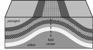
Nearly all of the rocks you see in Figures 1 and 2 above are sedimentary rocks (meaning they were formed through the deposition of sediments and hardened into rock over millions of years). One of the fundamental laws of geology (literally called “The Law of Original Horizontality”) states that sedimentary layers will be deposited horizontally. This makes sense: think about the flat bottom of a river or floodplain. If sediments were *not* deposited horizontally, just think of how crazy the world would be! Look back at Figure 1. If you look very closely, you’ll see that the sedimentary layers on side one and side two look slightly tilted. When sedimentary layers are tilted, this tells geologists that something happened to these rocks after their deposition. The layers on side one are pointing up towards side two. The layers on side two are pointing up towards side one. This is because these cliffs used to be part of a large rock fold. Yes! Rocks can fold into many different orientations when they are put under different stresses and strains (we’ll talk more about folds in the future!) Paradox Valley is a large anticline fold2. An anticline is a special type of fold where the youngest rock layers are on the top and the oldest rock layers are in the center of the fold. Think of it like this. If you place your hands on either side of a layered cake and push both hands toward the middle of the cake, the cake will bulge upward in an anticline fold (and you will be committing a major party foul)!
Mystery number three: where did the middle of the fold go?
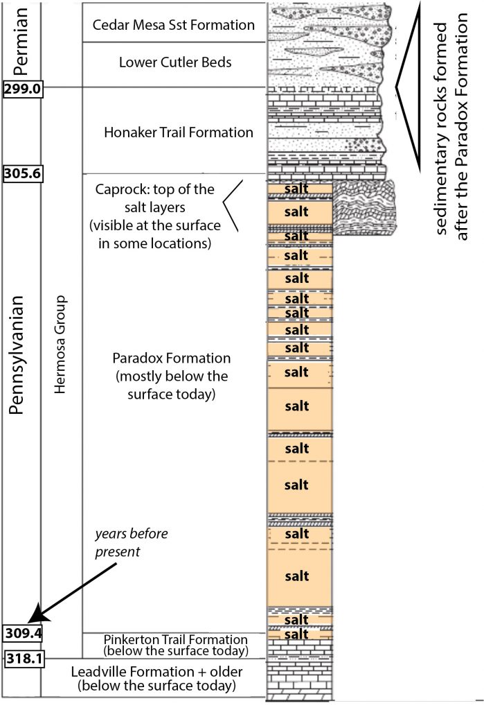
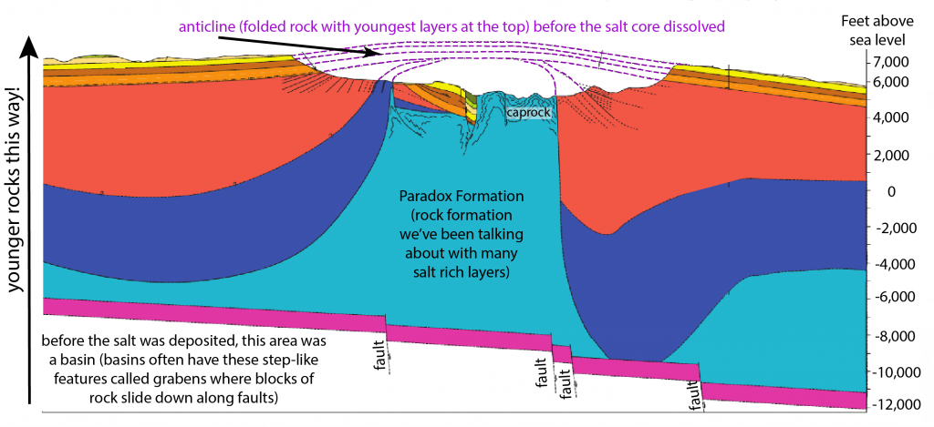
As you can see in Figure 3, it isn’t unusual for the middle of the fold to erode away. Any uplift of geologic material (whether it is through folding or mountain building), will encourage more erosion of that material. However, the story for Paradox Valley is pretty special in that the core of this anticline is largely made out of, you guessed it…..salt! Back about 310 million years ago (during the Pennsylvanian Period), the region where Paradox Valley sits was a marine basin at the base of the Ancestral Rocky Mountains4. Large amounts of salt (up to 2,500 meters thick!) were left behind as the water evaporated (this is similar to our post on Gypsum ). The salt makes up what is now called the Paradox Formation (in geology, we call layers of rock a “formation” when they have similar characteristics and were formed within a similar setting). Figure 4 is part of a stratigraphic column (a special column showing rock layers from oldest on the bottom to youngest on the top) of the Paradox Valley region – just look at all that salt in the Paradox Formation!
Salt is actually pretty weird in that it maintains its same density regardless of how deep you plunge it under the surface (most materials become denser as you push them deeper and increase the pressure on top of them)4. Changes in the stresses pushing down on the salt from materials overlying it can cause the salt to behave with a plastic-like nature. This can cause the salt to move vertically into the rock layers overlying it and, in the case of Paradox Valley, bulge the layers upward into an anticline fold. It’s likely that the salt was in motion for about 100 million years (from about 300 to 200 million years ago)4. Just like the salt you put in your afternoon tea (just kidding, gross), salt deposits can be dissolved when infiltrated with non-salty groundwater. When the salt in the center of the bulging anticline fold dissolved in Paradox Valley, the center of the fold collapsed forming a “salt valley”2,5. Many of these “salt valleys” exist along the border of Utah and Colorado, all remnants of ancient salt-cored anticline folds4.
Salty today, salty tomorrow
The Paradox Valley region is still very salty, as Paradox Formation salt deposits are still plentiful beneath the surface. This has created quite a geological engineering conundrum, as salt from these deposits has increased the salt content of regional groundwater. The salinity (saltiness) of the groundwater in this region is as high as 250,000 milligrams of salt per liter6 (seawater has a salinity of around 35,000 milligrams of salt per liter). This salty groundwater adds 205,000 TONS of salt to the Dolores River (a tributary of the very important Colorado River) every year. Geological engineers have removed the salt from this groundwater since 1996, injecting the salt instead into wells drilled into rocks deep below the surface. However, injection of this salt into the rock has resulted in an increased number of earthquakes in the region and the use of the injection well has been suspended since March 20196. Creative solutions are needed to keep the Dolores River from becoming too salty. Will you, geological engineers of the future, be the ones to find them?
References:
1Woodbury, George, and Edna Woodbury. “Archaeological survey of Paradox Valley and adjacent country in Western Montrose County, Colorado, 1931.” The Colorado Magazine 9.1 (1932): 1-21.
2Cater, Fred William, and Lawrence Carey Craig. “Geology of the salt anticline region in southwestern Colorado.” (1970).
3Spickermann, A., T. Schanz, and M. Datcheva. “Numerical modelling of primary stress states in deep seated slope problems.” 18th ABAQUS users’ conference. 2005.
4Trudgill, B. D. “Evolution of salt structures in the northern Paradox Basin: Controls on evaporite deposition, salt wall growth and supra‐salt stratigraphic architecture.” Basin Research 23.2 (2011): 208-238.
5King, Vanessa M., et al. “Geological structure of the Paradox Valley Region, Colorado, and relationship to seismicity induced by deep well injection.” Journal of Geophysical Research: Solid Earth 119.6 (2014): 4955-4978.
6Bureau of Reclamation. Paradox Valley Unit, 14 June, 2021, https://www.usbr.gov/uc/progact/paradox/index.html, accessed 6 August, 2021.
7United States Geological Survey. Saline water and Salinity, https://www.usgs.gov/special-topic/water-science-school/science/saline-water-and-salinity?qt-science_center_objects=0#qt-science_center_objects, accessed 6 August, 2021.
Special thanks to J. Zebulon Maharrey for sharing his interest in and knowledge of Paradox Valley with me!

